hale»studio 4.1.0: Multiple File Import, Spatial Indexing and more!


The hale»studio 4.1.0 release is here!
Based on customer feedback, we've brought in a host of exciting new changes. After months of hard work, we've made hale»studio a more powerful tool that now enables you to:
- Select multiple files during the schema and the data import
- Remove a single schema from the project view
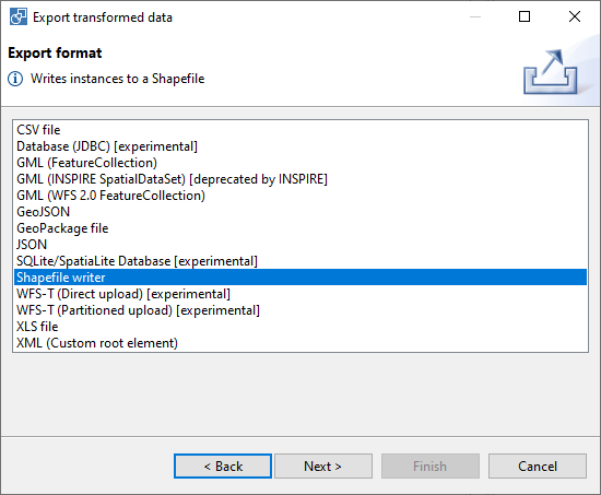
- Export the source and the transformed data to Shapefiles using GeoTools
- Work with presets for Environmental Noise Directive (END) schemas
- Create a spatial index when writing GeoPackage files
And of course, there are many other bug fixes (such as fixing the hale»studio launch in Mac OS 10.15.5 and above) and enhancements! You can find the complete changelog here.
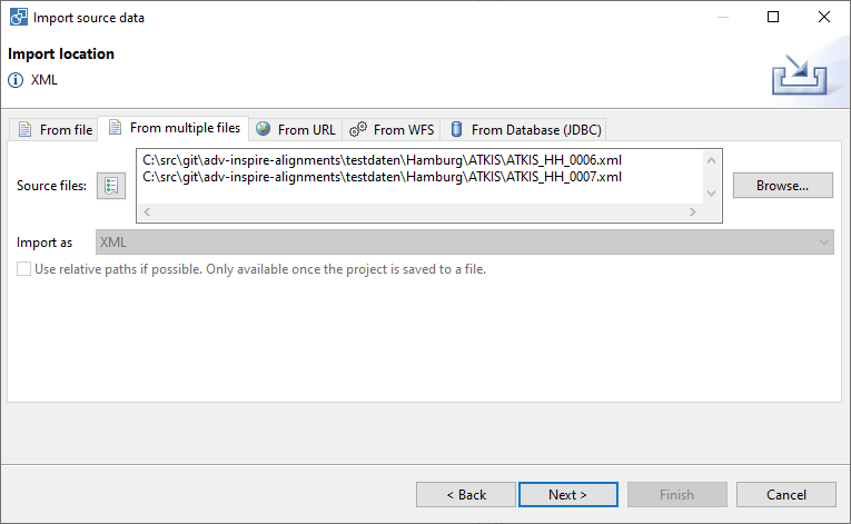
Multiple File Import
Until now, users could import only a single source schema or a single source data file at once in an import process. However, from this release, users can select multiple files during the schema import or when importing source data. This allows the user to save a significant amount of time when working with multiple files of the same format.
Shapefile File Export
This release enables users to export source or transformed data as a Shapefile, as shown below.
END Schema Presets
The END, introduced in 2002, monitors the effectiveness of EU emission controls by requiring the assessment of environmental noise at the Member State level. The deadline is in 2022, and almost 90% of the work is expected to be completed in the coming months.
The END consists of multiple application schemas that inherit from different INSPIRE themes. Given this closeness to INSPIRE, hale»studio has been used extensively for transforming data to END compliant formats, and we decided to add in schema presets to make the experience even better for those working on END datasets. A big thanks to the EEA who funded this development!
Spatial Index for GeoPackage Files
Some tools can't read a GeoPackage file unless the file has a spatial index. Moreover, it can be time consuming to retrieve and process spatial data through traditional comprehensive sequential scans. To combat these issues, hale»studio allows the user to create an index over the spatial data of their choice, resulting in better compatibility and faster processing.
The development work for this release was co-funded by the European Health and Digital Executive Agency (HaDEA) under Action No 2018-EU-IA-0093 (GO-PEG: Generation of cross border Pan European Geospatial Datasets and Services). And of course, a big thanks to the wetransform service team for their efforts through the months! See what we came up with below.
Download hale»studio
Download the latest version and send us your feedback:
To avoid any compatibility issues when using an existing workspace, we recommend starting with a fresh workspace when you install hale»studio 4.1.0.